

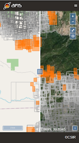
AFIS Wildfire Map

3.4star
127 reviews
10K+
Downloads

Everyone
info


About this app
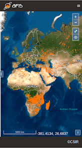
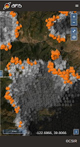
Get the latest updates on wildfire locations with the CSIR's AFIS Wildfire Map app that puts vital wildfire information at your fingertips. AFIS gives you access to fires detected globally by NASA's Terra and Aqua satellites as well as the SNPP and NOAA-20 satellites.
This app provides native access to the AFIS Viewer that is available online at https://viewer.afis.co.za/
This app replaces the previous AFIS app that was no longer maintainable. New features will be added over time.
Visit the South African Council for Scientific and Industrial Research (CSIR) website for more information about the organization behind AFIS: https://www.csir.co.za
Updated on
Safety starts with understanding how developers collect and share your data. Data privacy and security practices may vary based on your use, region, and age. The developer provided this information and may update it over time.


Ratings and reviews
3.4
126 reviews

Ashley Theron
- Flag inappropriate
October 6, 2021
The new app is very slow, says no internet although phone is connected to wifi. Sometimes doesn't show the current day FDI or will just close by itself. Please look into this, the old app was much better (web version as well as the new version doesn't have all the functions the old version had)
7 people found this review helpful
CSIR
October 15, 2021
Hi Ashley.
We have optimized some of the database queries to speed up the loading of the map. If you get the no internet error please refresh the app by dragging your finger from the top towards the bottom, like in most browsers. If that does not work please close the app completely and re-open. Let us know which features
you are missing.

L
- Flag inappropriate
July 16, 2021
Doesn't give any information (size, when spotted, containment, etc.) Seems accurate on a map, but without the additional info it's mostly useless.
3 people found this review helpful
CSIR
July 19, 2021
Thank you for your feedback. The app makes use of satellite data and the focus is on wide area (global) coverage rather than detailed information about each fire. Including the information you are referring to would require all responsible agencies world-wide to share information in an open and automated manner, which is unfortunately not the case.

Glen Logan
- Flag inappropriate
- Show review history
October 15, 2021
Tried what dev suggested, still for some reason get the no connection error. Connection speed is fine. I can only get the map to load when on wifi, anytime else it says no connection
CSIR
October 15, 2021
Sorry to hear that you are still experiencing the same issue. Can you try opening the viewer in your mobile device's browser? https://viewer.afis.co.za/map